L1S signal analysis with QZS L6 Tool
Introduction
The quasi-zenith satellite system (QZSS), Michibiki, broadcasts not only positioning signals but also signals to improve positioning accuracy and signals for disseminating disaster information. SLAS (sub-meter level augmentation service) messages broadcast in this L1 frequency band can now be displayed using QZS L6 Tool. I reviewed the code used in the research and incorporated it into this.
Obtaining SLAS messages
Michibiki’s L1S signal is available from u-blox’s NEO-M8T and ZED-F9P receivers, Sony Semiconductor’s Spresense board microcontroller, and so on. Using this augmented information, these receivers can not only perform positioning with an error of less than 1 meter, but also output the raw data used internally.
This L1S signal is currently being broadcast from all of the Michibiki in operation.
Here, we will use the SLAS archive on the Michibiki official page to obtain the data. If we enter the date and press the Search button on this site, download links for the day’s broadcasts from each Michibiki satellite will appear. We can also download all at once by clicking the Download! button. Download data is in units of one day for each satellite.
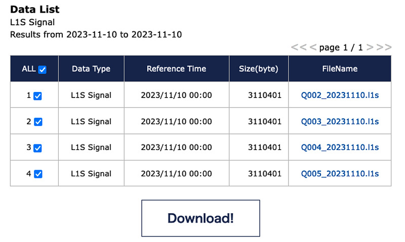
We can also specify the date and satellite and download directly using the curl command, without relying on the GUI.
Displaying SLAS messages
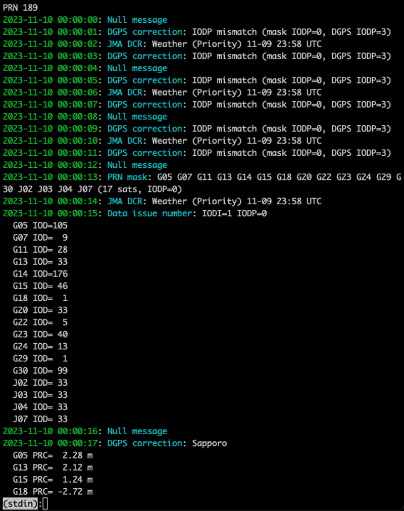
例えば、2023-11-10 00:00:00 UTCから23:59:59 UTCまでの1日間にて、みちびき3号機(QZS-3)が放送したL1Sメッセージを表示してみます。上述のサイトからアーカイブファイルQ003_20231110.l1sをダウンロードして、QZS L6 Toolのpythonディレクトリにある、qzsl1sread.pyを実行します。そのままでは、高速にメッセージが表示されて読めませんので、ページャーlvコマンドなどにパイプして、ゆっくり読めるようにします。コマンドlvとqzsl1sread.pyは、ともにカラー表示できますので、-cオプションにてカラー表示機能をオンにします。
curl https://sys.qzss.go.jp/archives/l1s/2023/Q003_20231110.l1s -o Q003_20231110.l1s
qzsl1sread.py -c Q003_20231110.l1s | lv -c
 For the command
 lv, press the space bar to advance to the next screen, press the b key to return to the previous screen, and press the q key to exit the display.
SLAS message content
SLAS messages consist of augmentation messages that improve positioning accuracy and disaster and crisis management report (DCR) messages that convey disaster information. When there is no information to send, a null message is broadcast. These message types are distinguished by a 6-bit message type (MT) number.
The use of augmentation messages is achieved by correcting the pseudorange (PR) from the receiver to the satellite that could be received (for example, GPS satellite 5 G05) by a correction value (PRC: pseudorange correction). will be done. In other words, all effects of satellite clock error, satellite orbit error, and tropospheric delay error are expressed in PRC.
A total of 13 observation points are available: Sapporo, Sendai, Hitachiota, Komatsu, Kobe, Hiroshima, Fukuoka, Tanegashima, Amami Oshima, Itoman (Okinawa), Miyakojima, Ishigakijima, and Chichijima (Ogasawara Islands). Of these, the coordinate information of up to 5 observation points will be notified in MT47’s monitoring station information. We are supposed to use the augmentation information of the nearest observation point available.
2023-11-10 00:00:48: Monitoring station information
  location 1: Hiroshima   34.350 132.450   50
  location 2: Fukuoka     33.600 130.230   50
  location 3: Tanegashima 30.550 130.940  100
  location 4: Amami       28.420 129.690   50
  location 5: Itoman      26.150 127.690  100
Here, the code numbers, latitude, longitude, and ellipsoid height of these five locations are notified. These coordinates were the same as those written in the specifications.
The specifications list GPS, QZSS, GLONASS, Galileo, and Hokuto as satellite systems, but in reality only GPS and QZSS seem to be used. First, up to 26 satellite candidates are defined with MT48’s PRN (pseudo random noise number) mask information. The number of candidate satellites here was the following 17 satellites.
2023-11-10 00:00:13: PRN mask: G05 G07 G11 G13 G14 G15 G18 G20 G22 G23 G24 G29 G
30 J02 J03 J04 J07 (17 sats, IODP=0)
The correspondence between the satellite PRN and the orbit information data issue number (IOD) will be notified in the data issue number of MT49. IOD indicates which orbital information is augmented for each satellite.
2023-11-10 00:00:15: Data issue number: IODI=1 IODP=0
  G05 IOD=105
  G07 IOD=  9
  G11 IOD= 28
  G13 IOD= 33
  G14 IOD=176
  G15 IOD= 46
  G18 IOD=  1
  G20 IOD= 33
  G22 IOD=  5
  G23 IOD= 40
  G24 IOD= 13
  G29 IOD=  1
  G30 IOD= 99
  J02 IOD= 33
  J03 IOD= 33
  J04 IOD= 33
  J07 IOD= 33
Finally, for each observation station, the PRC values of up to 14 satellites are transmitted using MT50’s DGPS (differential GPS) correction.
2023-11-10 00:00:17: DGPS correction: Sapporo
  G05 PRC=  2.28 m
  G13 PRC=  2.12 m
  G15 PRC=  1.24 m
  G18 PRC= -2.72 m
  G20 PRC= -1.96 m
  G30 PRC= -2.72 m
  J03 PRC= -1.04 m
  J04 PRC=  4.08 m
  J07 PRC= -1.28 m
In this example, there were 17 candidate satellites, and the number of satellites targeted for augmentation in Sapporo was 9.
In this way, in SLAS, instead of augmenting the MT50 DGPS correction message from the beginning, it decodes MT47, MT48, and MT49 in that order, and then decodes the MT50 message for each observation point.
Messages of disaster and crisis management report message can be found in the past related articles.
Related article(s):
- Using QZS L6 Tool from Docker 29th May 2026
- CLAS multistream transmission pattern ID 19th January 2026
- CLAS multi-stream test broadcast 1st July 2025
- Display of MADOCA-PPP ionospheric delay information using QZS L6 Tool 16th August 2024
- QZS L6 Tool output format change 14th April 2024
- Health information expression for QZSS 7-satellite configuration 12th April 2024
- Galileo Timing Service Message 6th April 2024
- Galileo HAS live stream 25th July 2023
- HAS message display capability on QZS L6 Tool 5th March 2023
- Trial delivery of QZSS's MADOCA-PPP started 18th August 2022
- Capacity analysis of CLAS satellite augmentation information using QZSS archive data 9th June 2022
- QZSS CLAS tropospheric delay augmentation information for remote islands in Japan 17th May 2022
- Compact SSR display capability on QZS L6 Tool 29th March 2022
- Release of QZS L6 Tool, a positioning satellite message display tool 3rd February 2022