RTK reference station (old page)
Summary
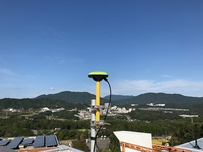
A RTK (realtime kinematic) reference station is in operation at Hiroshima City University.
RTK is a method that aims at positioning with a precision of several centimeters at a mobile station using GNSS radio wave observation results at a “reference station” with known latitude and longitude. GNSS signal observation results at the reference station are transmitted to the mobile station via the Internet or mobile radio communication. On the other hand, the GNSS signal is also observed at the mobile station, and the uncertainty of the positioning result at the mobile station can be reduced by correcting the observation result at the mobile station or elsewhere.
Real-time centimeter-order positioning can be expected using the observation data of the RTK reference station. For real-time positioning with the observation data, you may need a receiver measuring the carrier phase and an internet connection.
The observation data can be used for free without any prior notice. Please note that the service may be interrupted due to the software updates, equipment failures, power outages, and so on. The observation data cannot be used for official surveying.
RTK would be available at a location about 10 km from the reference station. You may use the observation data in most of places of central Hiroshima.
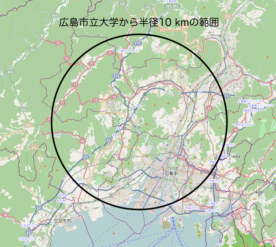
© OpenStreetMap contributors
You may find more RTK reference stations at Volunteer RTK reference stations other than this reference station.
Information for connection
Details are as follows:
| address and port | ntrip.phys.info.hiroshima-cu.ac.jp:80 |
|---|---|
| Service type | NTRIP Caster (version 1) |
| User name | none (blank) |
| Password | none(blank) |
| Protocol | RTCM 3.2 |
Following mount points are in public. Please use the mount point of OEM7 or F9P as an RTK reference station. Tutorial of using this reference station is also available.
| Mount point | OEM7 | F9P | ROV |
|---|---|---|---|
| Protocol | RTCM 3.2 | RTCM 3.2 | RTCM 3.2 |
| Satellite systems | GPS, GAL, GLO, QZS, BDS, IRN | GPS, GAL, GLO, QZS, BDS | GPS, GAL, GLO, QZS, SBAS |
| Frequency band | L1, L2, and L5 | L1 and L2 | L1 |
| Antenna position | Latitude 34.4401061 N Longitude 132.4147804 E Ellipsoidal height 233.362 m | same as left | Latitude 34.44010 N Longitude 132.41478 E Ellipsoidal height 232.4 m |
| Equipment | RTKLIB 2.4.3b34 u-blox ZED-F9P Javad GrAnt-G5T | RTKLIB 2.4.3b34 NovAtel OEM729 Javad GrAnt-G5T | RTKLIB 2.4.3b34 u-blox NEO-M8T (Emlid Reach) Beitian BT-200 |
| Comment | for reference station | for reference station | for positioning test |
Mount point F9PR is also broadcasted for the u-blox raw message regarding the mount point F9P.
The antenna positions were determined using the Hiroshima 2A station data of GSI of Japan during March 13rd - 17th 2021 (updated on 2021-03-27). The antennas are on the top of the Information Processing Center at Hiroshima City University (3-4-1 Ozuka-Higashi, Asa-Minami, Hiroshima, Japan).
The RTCM messages broadcasted from the server are as follows:
| Type | Description | OEM7 | F9P | ROV |
|---|---|---|---|---|
| 1005 | Station coordinates | 1 | 1 | |
| 1019 | GPS Ephemeris | on | on | on |
| 1020 | GLONASS Ephemeris | on | on | on |
| 1033 | Receiver and antenna descriptor | 1 | 1 | |
| 1041 | NavIC Ephemeris | on | ||
| 1042 | BDS Ephemeris | on | on | |
| 1044 | QZSS Ephemeris | on | on | on |
| 1045 | Galileo Ephemeris F/Nav (Free Navigation) | on | ||
| 1046 | Galileo Ephemeris I/Nav (Integrity Navigation) | on | on | on |
| 1077 | GPS MSM7 | 1 | 1 | 0.2 |
| 1087 | GLONASS MSM7 | 1 | 1 | 0.2 |
| 1097 | Galileo MSM7 | 1 | 1 | 0.2 |
| 1107 | SBAS MSM7 | 1 | 0.2 | |
| 1117 | QZSS MSM7 | 1 | 1 | 0.2 |
| 1127 | BeiDou MSM7 | 1 | 1 | |
| 1137 | NavIC MSM7 | 1 | ||
| 1230 | GLONASS L1/L2 code bias | on | on | on |
MSM7=Full pseudo-ranges, carrier phases, Doppler and signal strength, high resolution
Tutorial is presented for using famous freeware RTKLIB.
Observation data archive
You can obtain the archive data from below address:
https://phys.info.hiroshima-cu.ac.jp/gnss/f9p/
https://phys.info.hiroshima-cu.ac.jp/gnss/oem7/